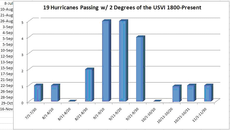
All Hurricanes
of the Virgin Islands from 1800-Present
| 1819, September 22
|
Very destructive in Virgin Islands and severe in Puerto Rico.
|
|||
1867, October 29
|
The most violent hurricane in many parts of Puerto Rico, known as San Narcisco. Accounts indicate it was a was a storm of small diameter and rapid movement. Also affected St. Thomas in the U.S. Virgin Islands |
|||
| 1876, September 13
|
A violent hurricane known as San
Felipe I. It struck St. Thomas and skirted the south coast of Puerto Rico.
|
|||
1889, September 3
|
A very destructive hurricane in
St. Thomas. It passed east of the U.S. Virgin Islands in a SE to NW
direction.
|
|||
| 1915, August 10-12
|
Hurricane skirted south coasts of St.Croix , U.S.V.I. and Puerto Rico in a E to W direction.
|
|||
| 1931, September 10-11
|
Violent hurricane known as San
Nicolas, passed through Virgin Islands and skirted north coast of Puerto Rico
in a E to W direction causing destruction along a strip 10 to 12 miles wide.
|
|||
| 1932, September 26-27
|
Destructive hurricane, known as
San Ciprian, passed through Virgin Islands and across Puerto Rico in a E to W
direction.
|
|||
| 1945, September 12-13
|
Hurricane passed within 2o latitude north of the Virgin Islands and Puerto Rico in a ESE to WNW
direction.
|
|||
| 1955, January 3
|
Hurricane Alice passed within 1o latitude southeast of St. Croix in the U.S.V.I. in a ENE to WSW direction.
|
|||
| 1960, September 4-6
|
Hurricane Donna passed within 1o latitude from St. Thomas in the U.S. Virgin Islands.
|
|||
| 1966, August 26
|
Hurricane Faith passed about 1o latitude northeast of the Virgin Islands in a E-SE to W-NW direction.
|
|||
1966, September 28
|
Hurricane Inez passed about 1o latitude south of Puerto Rico and St. Croix in a E to W direction.
|
|||
| 1989, September 17-18
|
Hurricane Hugo passed over St
Croix and St. Thomas...then Vieques and Culebra and the northeast corner of Puerto Rico in a
SE to NW direction.
|
|||
| 1995, September 5-6
|
Hurricane Luis passed just north
of U.S. Virgin Islands in a SE to NW direction.
|
|||
| 1995, September 15-16
|
Hurricane Marilyn passed over St.
Thomas in the U.S. Virgin Islands in a SE to NW direction.
|
|||
| 1996, July 8-9
|
Hurricane Bertha passed just
northeast of Puerto Rico and the U.S. Virgin Islands in a SE to NW direction.
|
|||
1997, September 5-8
|
Hurricane Erika passed about 2o latitude northeast of Puerto Rico and the U.S. Virgin Islands in a SE
to NW direction.
|
|||
| 1998, September 21-22
|
Hurricane Georges passed over St
Croix in the U.S. Virgin Islands and then entered Puerto Rico near Humacao
and traveled through the interior of the island exiting just south of
Mayaguez in Cabo Rojo. The hurricane traveled mainly in an E to W direction.
For Satellite picture click here and for storm report click here
|
|||
| 1999, November 16-18
|
Hurricane Lenny passed within 1o latitude to the south of Puerto Rico
and the U.S. Virgin Islands in a W to E direction and then eventually turned
E-NE over the northern Leeward Islands and into the Atlantic. For storm
report click here.
|
|||
| 2000, August 21-23
|
Hurricane Debby passed just north of St Thomas and within 1o latitude
to the northeast of Puerto Rico in an E-SE to W-NW direction. For storm
report click here.
|
|||
2008, October 15-16 |
Hurricane Omar had maximum sustained winds of 125 mph, but a last-second shift to the east meant that St. Croix experienced the weaker side of the system that passed just off Point Udall. |
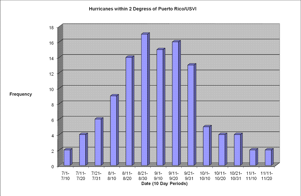
Tropical storms and
Hurricanes
which passed within two
degrees of latitude of
Puerto Rico and the
Virgin Islands from 1515 to present.
|
7/1-7/10 |
7/11-7/20 |
7/21-7/31 |
8/1-8/10 |
8/11-8/20 |
8/21-8/30 |
9/1-9/10 |
9/11-9/20 |
9/21-9/31 |
10/1-10/10 |
10/11-10/20 |
10/21-10/31 |
11/1-11/10 |
11/11-11/20 |
|||||
|
2 |
4 |
6 |
9 |
14 |
17 |
15 |
16 |
13 |
5 |
4 |
4 |
2 |
2 |
|||||
|
|
||||||||||||||||||
|
1515, July |
Exact date unknown. Caused death
of many Indians in Puerto Rico. |
|||
|
1526, October 4 |
Great damage in Puerto Rico. |
|||
|
1527, October 4 |
Affected Puerto Rico. |
|||
|
1530, July 26, August 23, August
31 |
These three storms within 6 weeks
blew down half the houses in San Juan, P.R. and unroofed the remainder. Many
cattle drowned. |
|||
|
1537, July and August |
Three hurricanes within 2 months
in Puerto Rico; exact dates unknown. Many slaves and cattle drowned. |
|||
|
1568, August 24 |
Affected Puerto Rico. |
|||
|
1575, September 21 |
Severe Hurricane, known as San
Mateo I in Puerto Rico. |
|||
|
1615, September 12 |
The most severe hurricane to
affect Puerto Rico in 40 years. (This suggests that other tropical storms may
have occurred between 1575 and 1615). |
|||
|
1738, September 12 |
Affected Puerto Rico. |
|||
|
1740, August |
Affected Puerto Rico; exact date
unknown. |
|||
|
1751, August 18 |
Affected Puerto Rico. |
|||
|
1767, August 7 |
Plantations destroyed and
livestock drowned in Puerto Rico. |
|||
|
1772, August 28 |
Affected Puerto Rico. |
|||
|
1780, October 14 |
Probably the most devastating
hurricane of record up to this date. It is known as "The Great
Hurricane". Passed over southwestern corner of Puerto Rico in a SE to NW
direction. |
|||
|
1785, September 25 |
A furious hurricane that passed
over Puerto Rico. |
|||
|
1788, August 16 |
Seriously affected Puerto Rico. |
|||
|
1804, September 21 |
This great hurricane known as San
Mateo II, remained in the memory of Puerto Ricans for a very long time. |
|||
|
1807, August 17-19 |
Severe hurricane from the east
lasted 50 hours in Puerto Rico. |
|||
|
1812, July 23, August 21 |
Seriously affected Puerto Rico. |
|||
|
1813, July 23 |
Affected Puerto Rico. |
|||
|
1814, July 22-23 |
Affected Puerto Rico. |
|||
|
1816 |
A violent hurricane passed over
Puerto Rico; exact date unknown. |
|||
|
1818, September 22 |
Seriously affected Puerto Rico. |
|||
|
1819, September 22 |
Very destructive in Virgin Islands and severe in Puerto Rico.
|
|||
|
1825, July 26-27 |
A very violent hurricane, known as
Santa Ana, which was very destructive in Puerto Rico. |
|||
|
1827, August 18-19 |
Very destructive hurricane crossed
Puerto Rico in a SE to NW direction. |
|||
|
1827, August 28 |
Affected Virgin Islands severely,
especially St. Thomas.
|
|||
|
1830, August 11-12 |
Severely affected St. Thomas in
the U.S. Virgin Islands.
|
|||
|
1835, August 13 |
Crossed Puerto Rico in a ESE to
WNW direction. |
|||
|
1837, July 31 |
Severely affected St. Thomas in
the U.S. Virgin Islands.
|
|||
|
1837, August 2-3 |
A violent hurricane, known as Los
Angeles, struck St. Thomas and skirted the northeastern coast of Puerto Rico
in a ESE to WNW direction.
|
|||
|
1840, September 16 |
Severely affected Puerto Rico. |
|||
|
1846, September 12-13 |
Passed by northeastern corner of
Puerto Rico in a SE to NW direction. |
|||
|
1851, August 18-19 |
A violent hurricane, known as
Santa Elena,(also known as San Agapito) skirted the south coast and crossed
the southwestern corner of Puerto Rico in a ESE to WNW direction. |
|||
|
1852, September |
Affected Puerto Rico; exact date
unknown. |
|||
|
1867, October 29
|
The most violent hurricane in many
parts of Puerto Rico, known as San Narcisco. Accounts indicate it was a was a
storm of small diameter and rapid movement. Also affected St. Thomas in the
U.S. Virgin Islands where 1,000 lives were lost.
|
|||
|
1876, September 13 |
A violent hurricane known as San
Felipe I. It struck St. Thomas and skirted the south coast of Puerto Rico.
|
|||
|
1889, September 3
|
A very destructive hurricane in
St. Thomas. It passed east of the U.S. Virgin Islands in a SE to NW
direction.
|
|||
|
1891, August 19-20 |
Hurricane crossed eastern Puerto
Rico in a SE to NW direction. |
|||
|
1893, August 16-17 |
Hurricane passed Puerto Rico in a
ESE to WNW direction. |
|||
|
1896, August 31- September 1 |
Hurricane crossed southwestern
corner of Puerto Rico in a SE to NW direction. |
|||
|
1898, September 21-22 |
Tropical Storm crossed
northeastern Puerto Rico in a ESE to WNW direction. |
|||
|
1899, August 7-8 |
Disastrous hurricane known as San
Ciriaco, crossed Puerto Rico in a ESE to WNW direction. |
|||
|
1900, August 30- September 1 |
Tropical storm skirted south coast
of Puerto Rico in a E to W direction. |
|||
|
1900, October 24-26 |
Tropical storm crossed
southwestern corner of Puerto Rico in a SE to NW direction. |
|||
|
1901, July 6-8 |
Hurricane crossed southwestern
Puerto Rico in a SE to NW direction. |
|||
|
1901, September 11-13 |
Tropical storm skirted north coast
of Puerto Rico in a SE to NW direction. |
|||
|
1901, October 8-10 |
Tropical storm crossed
northeastern corner of Puerto Rico in a SE to NW direction. |
|||
|
1903, July 19-20 |
Tropical storm crossed Puerto Rico
in a ESE to WNW direction. |
|||
|
1908, September 9-10 |
Hurricane passed off north coast
of Puerto Rico in a E to W direction. |
|||
|
1908, September 26-27 |
Tropical storm passed off south
coast of Puerto Rico in a E to W direction. |
|||
|
1909, November 12-13 |
Tropical storm passed off
northwestern corner of Puerto Rico in a WSW to ENE direction. |
|||
|
1910, August 24-25 |
Tropical storm passed off south
coast of Puerto Rico in a E to W direction. |
|||
|
1910, September 6-7 |
Hurricane skirted south coast of
Puerto Rico in a E to W direction. |
|||
|
1915, August 10-12 |
Hurricane skirted south coasts of
St.Croix , U.S.V.I. and Puerto Rico in a E to W direction.
|
|||
|
1916, July 12-14 |
Tropical storm passed through Virgin Islands in a SE to NW direction.
|
|||
|
1928, September 13 |
Devastating Hurricane San Felipe
II passed through Puerto Rico in a SE to NW direction. |
|||
|
1931, August 17 |
Tropical storm crossed Puerto Rico
in a SE to NW direction. |
|||
|
1931, September 10-11 |
Violent hurricane known as San
Nicolas, passed through Virgin Islands and skirted north coast of Puerto Rico
in a E to W direction causing destruction along a strip 10 to 12 miles wide.
|
|||
|
1932, September 26-27 |
Destructive hurricane, known as
San Ciprian, passed through Virgin Islands and across Puerto Rico in a E to W
direction.
|
|||
|
1933, July 25-26 |
Tropical storm passed just
northeast of Virgin Islands in a ESE to WNW direction.
|
|||
|
1933, September 27-28 |
Tropical storm passed within 1o
latitude south of Puerto Rico in a E to W direction. |
|||
|
1934, August 21-22 |
Tropical storm passed within 2o
latitude south of Puerto Rico in a E to W direction. |
|||
|
1934, September 18 |
Tropical storm passed within 2o
latitude northeast of Virgin Islands in a SE to NW direction. |
|||
|
1937, August 24-25 |
Tropical storm passed within 2o
latitude northeast of Virgin Islands in a ESE to WNW direction. |
|||
|
1938, August 8 |
Tropical storm passed through
Virgin Islands and skirted north coast of Puerto Rico in a E to W direction.
|
|||
|
1939, August 7 |
Tropical storm apparently
developed about 1o latitude northeast of St. Thomas in the U.S.V.I. and moved
northwestward.
|
|||
|
1940, August 5 |
Tropical storm passed just north
of St. Thomas in the U.S.V.I. in a ESE to WNW direction.
|
|||
|
1942, November 4 |
Tropical storm apparently
developed just off southeastern Puerto Rico and crossed the northeastern part
of the island in a ESE to WNW direction. |
|||
|
1943, August 13-14 |
Tropical storm passed just
northeast of St. Thomas in the U.S.V.I. in a ESE to WNW direction.
|
|||
|
1943, October 14 |
Hurricane passed between
Hispaniola and Puerto Rico in a S to N direction. |
|||
|
1944, July 12-13 |
Tropical storm apparently
developed just off the northwest corner of Puerto Rico and moved
northwestward. |
|||
|
1945, August 3 |
Tropical storm passed within 1o
latitude of the southwestern corner of Puerto Rico in a ESE to WNW direction. |
|||
|
1945, September 12-13 |
Hurricane passed within 2o
latitude north of the Virgin Islands and Puerto Rico in a ESE to WNW
direction.
|
|||
|
1947, October 16-17 |
Tropical storm passed just
northeast of St. Thomas in the U.S.V.I. in a SE to NW direction.
|
|||
|
1949, September 2-3 |
Tropical storm developed between
Puerto Rico and the Virgin Islands and moved northwest, reaching hurricane
intensity and changing course to northward after passing 20o N
latitude on the 3rd day.
|
|||
|
1950, August 23 |
Tropical storm passed over the
southwest corner of Puerto Rico in a ESE to WNW direction. |
|||
|
1953, September 14 |
Tropical storm Edna passed within
1o latitude northeast of the Virgin Islands in a SE to NW
direction.
|
|||
|
1954, August 30-31 |
Tropical storm Dolly formed just
off the northwestern corner of Puerto Rico and moved off in NNW direction. |
|||
|
1955, January 3 |
Hurricane Alice passed within 1o
latitude southeast of St. Croix in the U.S.V.I. in a ENE to WSW direction.
|
|||
|
1955, September 11-12 |
Tropical storm Hilda passed within
1o latitude north of St. Thomas in the U.S.V.I. in a ESE to WNW direction
reaching hurricane intensity on the 12th.
|
|||
|
1956, August 11-12 |
Hurricane Betsy (Santa Clara)
crossed Puerto Rico in a SE to NW direction. |
|||
|
1958, September 13-14 |
Tropical Storm Gerda passed about
1o latitude from southwestern corner of Puerto Rico in a ESE to
WNW direction |
|||
|
1959, August 18-19 |
Tropical Storm Edith passed within
1o latitude south of Puerto Rico and the U.S. Virgin Islands from
a E to W direction.
|
|||
|
1960, September 4-6 |
Hurricane Donna passed within 1o
latitude from St. Thomas in the U.S. Virgin Islands.
|
|||
|
1961, October 2-3 |
Hurricane Frances passed within 1o
latitude from the southwestern corner of Puerto Rico in a SE to NW direction |
|||
|
1963, September 26-27 |
Hurricane Edith headed due N
toward the southwestern tip of Puerto Rico and then turned due W just before
making land. |
|||
|
1964, August 22-23 |
Hurricane Cleo passed within 2o
latitude south of Puerto Rico from a E to W direction. |
|||
|
1965, August 28-29 |
Tropical Depression turned into
Tropical Storm Betsy within 2o latitude E -NE of U.S. Virgin
Islands in a S to N direction. Shortly afterwards it became Hurricane Betsy.
|
|||
|
1966, August 26 |
Hurricane Faith passed about 1o
latitude northeast of the Virgin Islands in a E-SE to W-NW direction.
|
|||
|
1966, September 28 |
Hurricane Inez passed about 1o
latitude south of Puerto Rico and St. Croix in a E to W direction.
|
|||
|
1967, September 9-10 |
Hurricane Beulah passed within 1o
southwest of southwestern corner of Puerto Rico in a SE to NW direction. |
|||
|
1973, September 3-4 |
Tropical Storm Christine weakened
into a tropical depression before passing over the northern U.S. Virgin
Islands and just northeast of the NE tip of Puerto Rico. It dissipated
shortly afterwards.
|
|||
|
1974, August 29-30 |
Tropical Depression developed into
Tropical Storm Carmen as it passed about 1o south of Puerto Rico
in a E to W direction. |
|||
|
1975, September 15 |
Tropical Depression developed into
Tropical Storm Eloise just as it reached within 1o north of the
northeastern tip of Puerto Rico as it passed in a E to W direction. |
|||
|
1979, July 17-18 |
Tropical Storm Claudette passed
over northern U.S. Virgin Islands and weakened to a Tropical Depression just
as it hit the northeast coast of Puerto Rico. It then traveled right along
the northern coastline of Puerto Rico in a E to W direction.
|
|||
|
1979, August 30 |
Hurricane David passed about 1o
latitude south of Puerto Rico in a E-SE to W direction. |
|||
|
1979, September 3-4 |
Tropical Storm Frederic passed
over St. Croix and then traveled right along the southern coast of Puerto
Rico in a E to W direction.
|
|||
|
1981, September 4 |
Tropical Storm Floyd passed within
1o latitude of northern U.S. Virgin Islands in a SE to NW
direction.
|
|||
|
1981, September 8 |
Tropical Storm Gert passed just
near St. Croix and then over the northeast corner of Puerto Rico in a SE to
NW direction. |
|||
|
1984, November 6-7 |
Tropical Storm Klaus passed just
between Puerto Rico and the U.S. Virgin Islands in a SW to NE direction.
|
|||
|
1987, September 22 |
Hurricane Emily passed almost 2o
latitude southwest of Puerto Rico in a SE to NW direction. |
|||
|
1988, September 10 |
Tropical Storm Gilbert turned into
Hurricane Gilbert as it passed about 2o latitude south of Puerto
Rico in a SE to NW direction. |
|||
|
1989, August 3-4 |
Hurricane Dean passed almost 2o
northeast of Puerto Rico in a SE to NW direction. |
|||
|
1989, September 17-18 |
Hurricane Hugo passed over St
Croix and St. Thomas...then Vieques and Culebra and the northeast corner of Puerto Rico in a
SE to NW direction.
|
|||
|
1990, October 7 |
Tropical Storm Klaus passed just
northwest of northern U.S. Virgin Islands in a E-SE to W-NW direction.
|
|||
|
1993, August 16 |
Tropical Storm Cindy passed almost
2o southwest of Puerto Rico in a SE to NW direction. |
|||
|
1995, September 5-6 |
Hurricane Luis passed just north
of U.S. Virgin Islands in a SE to NW direction.
|
|||
|
1995, September 15-16 |
Hurricane Marilyn passed over St.
Thomas in the U.S. Virgin Islands in a SE to NW direction.
|
|||
|
1995, October 23-24 |
As Tropical Storm Sebastien passed
within 1o latitude southeast of U.S. Virgin Islands it weakened to
a tropical depression and then dissipated just SE of Puerto Rico as it moved
in a NE to SW direction.
|
|||
|
1996, July 8-9 |
Hurricane Bertha passed just
northeast of Puerto Rico and the U.S. Virgin Islands in a SE to NW direction.
|
|||
|
1996, September 9-10 |
Hurricane Hortense passed over the southwest corner of Puerto Rico in
a SE to NW direction. For storm summary click here
|
|||
|
1997, September 5-8 |
Hurricane Erika passed about 2o
latitude northeast of Puerto Rico and the U.S. Virgin Islands in a SE
to NW direction.
|
|||
|
1998, September 21-22 |
Hurricane Georges passed over St
Croix in the U.S. Virgin Islands and then entered Puerto Rico near Humacao
and traveled through the interior of the island exiting just south of
Mayaguez in Cabo Rojo. The hurricane traveled mainly in an E to W direction.
For Satellite picture click here and for storm report click here
|
|||
|
1999, October 20-21 |
Tropical Storm Jose passed within 1o latitude to the northeast of
Puerto Rico and the U.S. Virgin Islands in a E-SE to W-NW direction and then
turned N-NE once in the Atlantic to the north of our local islands. For storm
report click here.
|
|||
|
1999, November 16-18 |
Hurricane Lenny passed within 1o latitude to the south of Puerto Rico
and the U.S. Virgin Islands in a W to E direction and then eventually turned
E-NE over the northern Leeward Islands and into the Atlantic. For storm
report click here.
|
|||
|
2000, August 21-23 |
Hurricane Debby passed just north of St Thomas and within 1o latitude
to the northeast of Puerto Rico in an E-SE to W-NW direction. For storm
report click here.
|
|||
|
2001, August 22-23 |
Tropical Storm Dean formed from a
tropical wave over the Virgin Islands on August 22nd and a Hurricane Hunter
plane indicated winds near hurricane force later that day. The system
encountered an unfavorable environment the next day north of Puerto Rico and
weakened to a tropical wave. Winds to tropical storm force were reported in
the U.S. Virgin Islands and there was an estimated $2 million in damage due
to flooding in Puerto Rico.
|
|||
| 2004, September 15-16
|
Tropica Storm Jeanne passed just south of St Croix and then entered
southeast Puerto Rico near Maunabo and traveled west then north and west
again across Puerto Rico and exited over the northwest tip of the island near
Aguadilla. For storm report click here.
|
|||
|
2008, October 15-16 |
Hurricane Omar had maximum sustained winds of 125 mph, but a last-second shift to the east meant that St. Croix experienced the weaker side of the system that passed just off Point Udall. |
(c) C. Hartmann, 2009